Why Death Valley Is Full of Polygons
Salt flats, deserts, and dry lakes host mysterious and still unexplained patterns of interlocked polygons formed from narrow ridges that grow on the salt-encrusted ground. Now researchers believe they can explain how these patterns form through the interaction between fluid flowing in the soil and fluid evaporating at the surface [1]. The new work appears to offer a unifying explanation for the growth of such polygons in a wide range of different physical conditions.
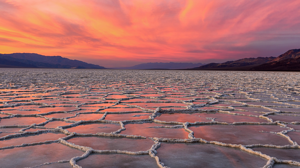
Salt polygons form in regions where the rate of evaporation of water from the ground significantly exceeds the rate of precipitation. In such places, evaporation at the surface is balanced by a continuous flow of groundwater from more distant sources. For example, Badwater Basin in Death Valley, California, is supplied by water from the nearby mountains. This water rises to the surface and leads to continuous evaporation, even in the absence of rainfall, and it leaves a salt residue behind. But why these residues form into ridges that trace out polygonal patterns has remained mysterious. Also puzzling is why the patterns turn out to be so similar wherever they occur, despite local differences in geology, salt chemistry, and environmental conditions.
“Salt deserts are some of the most beautiful landscapes in the world,” says physicist Jana Lasser of the Graz University of Technology in Austria. The polygons are “always a few meters across, but no one has been able to explain the origins of these patterns with their distinctive size and shape.”
To find an explanation, Lasser and her colleagues developed a mathematical model of the processes occurring at and just beneath the surface. This model, based on fluid dynamics and other geophysical principles, predicts that a typical dry lake bed will develop a heavy salt-rich layer of fluid near its surface as a result of the salty residue above.

This dense, salty layer rests unstably on top of less-dense fluid below. If the driving force of evaporation is sufficiently strong, a convective flow develops in the fluid: saltier water sinks and less-salty water rises, which generates upward- and downward-flowing columns of fluid, like those that appear in boiling water. Using fluid parameters characteristic of real salt lake beds, the researchers predict these so-called convection rolls to be roughly 1–2 m across—suspiciously similar to the sizes of observed polygons.
In simulations, the team went further to study the long-term evolution of this fluid flow. The simulations show that the convection rolls ultimately generate a set of narrow plumes of high-salinity water descending from the surface. These plumes then form into a closed polygonal network of downwelling vertical sheets that surround patches of upwelling fluid.
This network of convection rolls, Lasser says, drives the formation of the salt ridges. In the interior of each convection cell, where low-salinity water flows upward, the salt crust grows more slowly because it is in contact with less-salty water. In contrast, at the cell boundaries located directly above the downwelling sheets, a higher flux of salt flows upward into the crust. As a result, narrow ridges grow rapidly and build the polygonal network pattern.
To test this model, Lasser and her colleagues used detailed simulations of the fluid dynamics model and compared these with observations from field sites, including Death Valley. Excavating beneath the ridge pattern, they found evidence of salty, down-flowing plumes, exactly as predicted, with fresher water flowing upward in the flat centers of the polygons. Overall, the researchers found that their model could explain not only the basic emergent patterns, but also the key length scales—the widths of both the convective cells and the salt ridges.
“This research presents compelling evidence that salt polygons are the surface signature of this convection mechanism,” says mathematician Duncan Hewitt of University College London. “It’s a rather beautiful result, which provides a potential explanation for a widely observed geological pattern.”
–Mark Buchanan
Mark Buchanan is a freelance science writer who splits his time between Abergavenny, UK, and Notre Dame de Courson, France.
References
- J. Lasser et al., “Salt polygons and porous media convection,” Phys. Rev. X 13, 011025 (2023).