Predicting Heatwaves’ Highest Temperatures
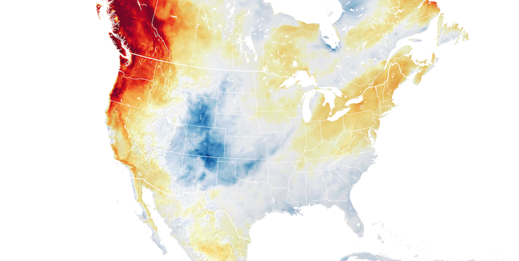
The heatwave that beset the Pacific Northwest in the summer of 2021 was among the most severe and deadly ever recorded. When the heatwave began, atmospheric physicist Yi Zhang was about to start her postdoc at the University of California, Berkeley. As the temperature rose, she and her Berkeley collaborator, William Boos, sought an explanation for the unusual event. Their investigation, which has just been published, culminated instead in a general theory that accounts for the maximum surface temperature reached during heatwaves at midlatitudes—the temperate zones between 30° and 60° latitude north or south of the equator [1]. The theory also predicts how much hotter—and potentially more deadly—heatwaves will become as Earth’s climate warms.
Meteorologists have identified the conditions that beget heatwaves at midlatitudes. A zone of high-pressure air forms over land and drives an anticyclone that circulates around it. Under pressure, the air at the center warms and becomes less likely to produce clouds that would otherwise shade and cool the surface. In the Northern Hemisphere, winds tend to push anticyclones eastward. But if meteorological conditions prevent an anticyclone from moving, the temperature keeps rising. Zhang and Boos set out to determine what physical processes arrest the rise.
The lowest layer of Earth’s atmosphere is called the troposphere. There, gravity causes the atmospheric density and, with it, the temperature to decrease with altitude. If a parcel of air becomes hotter than its surroundings, its lower density will boost its buoyancy and drive air movement by convection. Even in a heatwave, air in the bottom 1–2 km of the atmosphere—the so-called boundary layer—will become buoyant enough to rise and transport its energy upward. To that basic picture, Zhang and Boos added two ingredients that were essential to their theory.
The first ingredient was the recognition that surface air, even in the dry conditions of a heatwave, contains enough moisture to behave like a convection cell—a phenomenon in which circuits of moist air moving up and down eventually lead to precipitation—in a summer thunderstorm. The pressure at which that occurs was the second essential ingredient. Such pressure should be low enough for surface air to be convectively coupled to the boundary layer yet high enough that its temperature is not affected by the surface. Those criteria are met at an atmospheric pressure of 500 hPa, which corresponds to an altitude of 5–7 km.
According to Zhang and Boos’s theory, the maximum daily temperature during a heatwave stops rising when convection carries moist air aloft to the 500-hPa level. Even if the resulting rain evaporates before it reaches the surface, its cooling effect is strong enough to cause the temperature to start falling.
Zhang and Boos’s theory explains the three most severe heatwaves of the past two decades—the 2021 Pacific Northwest heatwave, the 2010 Russian heatwave, and the 2019 European heatwave. In particular, their theory could account for almost all of the 5 ºC peak-temperature anomaly of the Pacific Northwest heatwave.
“This is a significant paper!” says Michael Byrne of the University of St. Andrews, Scotland. He points out it’s the latest in a recent series of papers on how convective dynamics constrain average and extreme temperatures over land and the first to apply these ideas to very hot days in midlatitude regions.
The key independent variable in Zhang and Boos’s theory is the temperature at the 500-hPa level, T500. Meteorological models can forecast T500 with reasonable accuracy up to three weeks in advance, meaning that the theory could deliver reliable warnings of deadly heat.
The theory can also be used to predict climate change impacts. By differentiating their formula for the peak surface temperature, Ts,max, with respect to T500, Zhang and Boos determined how Ts,max would increase as climate change raises T500. Their projections are grim: the highest temperatures attained during midlatitude heatwaves will increase at about twice the rate of the mean atmospheric temperature.
–Charles Day
Charles Day is a Senior Editor for Physics Magazine.
References
- Y. Zhang and W. R. Boos, “An upper bound for extreme temperatures over midlatitude land,” Proc. Natl. Acad. Sci. U.S.A. 120 (2023).


